
Last month I received an email from Chris Howlett with some interesting news:
A couple of years ago I was involved in a major bathymetric survey of the Normandy beaches in which we attempted to locate and classify all wrecks along the 5 beaches. One of the wrecks we covered was that of the USS Partridge. Next year a team of divers is planning to visit some of the wrecks located and the Partridge is on the list – although sea and weather conditions may mean the divers do not visit her remains.
We are putting together a book of the wrecks that we cover and it would be very interesting to use some of the information on your site – not too much as each wreck will get only a couple of pages but some of the accounts of the sinking would be useful as would some of the photos. In return I can let you have some sonar images of the wreckage and possibly some underwater photos of the wreckage (if the divers get there) should these be of interest and use to you.
I came across the Partridge a while ago when I was researching the Mulberry harbours and her sinking is mentioned in some of the diaries of the harbour groups.
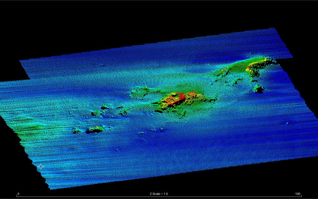
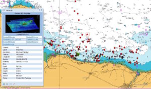
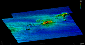
Chris was good enough to send along sonar images of the Partridge on the bottom of the Channel along with a detailed map of other wreckages.
As you can see, there seems to be little that is identifiable in the images but maybe the divers will see something that the sonar could not. In the location image the Partridge is represented by a red dot (for shipwreck) and is pretty much dead centre of the image. In the file Partridge location copy the wreck is identified by the rather crudely drawn square surrounding it.All the other red circles, hashes and other symbols represent other shipwrecks and wreckage that we located during the survey.
I have just returned from a diving trip to Normandy. And think that we dived the Partridge. Very little remaining above the sand except for the 2 3″ guns and the boilers. Is there any information that I can supply?
My mother’s favorite cousin, Harry Dix, went down with the Partridge. Mom is 91. One of my sisters will probably be in England some time in the next few months, might even get to the waters near where the Partridge went down. For us, any information, anecdotes about the dive, photos if you have any–would be much appreciated.
Hello James,
I’m one of the divers that Chris mentions. We are divers from Southsea Sub-Aqua club and have completed a total of 3 expeditions (1 in 2017 and 2 in 2018) to record D Day wrecks. We have also been very fortunate to work with the French heritage agency as part of their survey of the wrecks of the Normandy campaign in support of the application for UNESCO World Heritage site status. Sadly we did not get to dive the wreck of the USS Partridge but we did manage to dive the wreck of what may be the other tug lost on 11 June (HMRT Sesame). We are planning another expedition next July (2019) when we hope to survey Partridge and Sesame in more detail. We will be submitting an application to the French authorities for permission to undertake this work very shortly. We will of course share our findings with you. More information of our other projects can be found on our web site http://www.southseasubaqua.org.uk/diving-projects Kind regards
Look what we arrange an eye to you! a fineoffers
Well-founded click
https://drive.google.com/file/d/1tTSaTlafiCEwxxX5JC7J3fFYLZNDmNoW/preview
Looks like the scuba visit will be in July 2019
http://www.southseasubaqua.org.uk/images/diving_projects/Tale_of_Two_Tugs/Two-Tugs-Plan-English-version.pdf
Note that the expedition to the Partridge will occur next month ( July 2019)
See referenced details on dates and plans in the link
http://www.southseasubaqua.org.uk/images/diving_projects/Tale_of_Two_Tugs/Two-Tugs-Plan-English-version.pdf
Today is the 75th anniversary of the sinking of the USS Partridge. Thinking of my mother’s cousin Harry (“Sam”) Dix, who went down with the Partridge. Allison, is the dive you mentioned still happening next month?
Hello,
Alison and the divers are diving the USS Partridge now (25 July 2019).
Hello Al, Sorry but I didn’t see your comment/question until visiting this site today. The comments/questions don’t automatically get sent to me. Our expedition project to survey the wrecks of USS Partridge and HMRT Sesame has been successfully completed. We are now analysing the large amount if data and hope to finish our report by end November 2019. There is a possibility that we will be back at the end of August for one more dive (weather permitting).
The dives were very good with lots to see and full of marine life. A very lovely site and a privilege to visit. From what we can tell the site is seldom dived as it is close to a much more famous wreck (Susan B Anthony). It was therefore very peaceful to visit.
We are in contact with Robert Neyland Head of the Underwater Archaeology Branch, Naval History and Heritage Command, to ask for any details of the ship’s plans. We are trying to match various parts of the wreck/artefacts with those on the ship’s plans/drawings to help confirm the wreck as that of the USS Partridge. In particular the two guns and boiler arrangements.
Whilst we were there we held a commemorative event to remember all those that were lost in the Normandy campaign. We also visited the US Cemetery to pay respects to those who made the ultimate sacrifice.
If you have any further information that may help us with our investigations please let me know. We will make available the report once completed.
Kind regards
Alison
I welcome any photos or information. The lost Soldiers stories need to be told and remembered. My mother’s brother Ernest Gutierrez remained below deck notifying land of the attack. I was told his body was never recovered and our family has always felt lost of no place to honor him. Thank you for your efforts. Patricia Garvia
Dear all,
Our diving expedition to survey the wreck has now completed and we are collating the data and conducting research to report our findings. The wreck is extremely interesting and is challenging us in many ways. Conditions for the survey were very good and we have lots of data to process. It is a very interesting wreck and absolutely teeming with marine life.
What would really help is a copy of the ship plans for Partridge or one of her sister ships (Lapwing class). I have written to the Hampton Roads museum and also the US Navy heritage command but no luck so far. Do you know how I can obtain a copy?
Our report to the French underwater archaeology dept (known as DRASSM) is due by end November (in English and French). I am happy to share this when completed.